![]()
Land | Climate | People | Economy | Getting Here
| Capital | Halifax |
| Official Languages | English |
| Population | 934,405 |
| Time Zone | UTC-4 |
Nova Scotia - Canada's Ocean Playground - is a delightful destination which has been charming visitors with scenery, history, hospitality and a unique way of life for more than a hundred years.
Here you can hear the crash of wave on rock, the whisper of a cool summer breeze, the cry of the wheeling gull around a fishing wharf, and the rhythm of endless waves rolling into quiet picturesque coves.
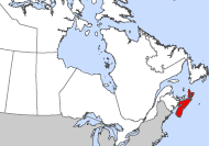
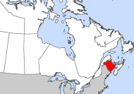
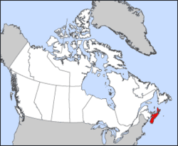
The province is 2,425 square miles in area and is 350 miles in length. Its coast is washed by the Atlantic Ocean, the Bay of Fundy, the Northumberland Strait (it's known to boast the warmest salt water north of the Carolinas), and the Gulf of St. Lawrence. It is a peninsula adjoined by Cape Breton Island and linked by the Isthmus of Chignecto to New Brunswick.
The climate is maritime, tempered by the presence of the sea. It is neither too hot in summer nor too cold in winter. The average temperature is 22°C (72°F) in Halifax in July and 0°C (31°F) in January.
With the Atlantic Ocean never more than 40 miles away, and lakes, streams, and rivers even closer, you can enjoy water sports, fishing, boating, canoeing, swimming, and excellent outdoor activities. Countless bays, coves, inlets and harbours provide some of the best sailing in North America, excellent scuba diving, wind surfing and sea kayaking. Nova Scotia is one of the finest places on the eastern seaboard for whale and bird watching. Around every bend, a new treasure awaits the explorer.
Nova Scotia's largest lake, the Bras d’Or Lake (450sq.mi) is known for its gentle, fog-free waters, great anchorages, and hundreds of coves and islands, the Bras d'Or Lakes are an international cruising and sailing destination.
The province is remarkably easy to get around in. Besides its good access from the sea, the province has a well-developed network of highways and roads from one end of the province to the other.
As you travel Nova Scotia may you be met by the traditional Gailic greeting - CIAD MILE FAILTE - one hundred thousand welcomes. "Bluenosers" are open, friendly and willing to share in the culture and good times of their province.
The spectacular beauty of the Atlantic seaboard offers incredibly affordable real estate opportunities for vacationers, investors, and retirees. With direct air access to several international airports travel is reasonably priced and uncomplicated. Within a few hours you can easily settle into your second home to enjoy the hospitality and charm of the east coast.
Land
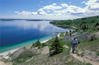 Walking the coastline of Nova Scotia
 Nova Scotia's 580-kilometre-long peninsula is surrounded by four bodies of water - the Atlantic Ocean, the Bay of Fundy, the Northumberland Strait and the Gulf of St. Lawrence. Its geographic location, together with large, ice-free, deep-water harbours, has been a key factor in the province's economic development.
With an area of 55 491 km2, Nova Scotia is larger than Denmark, although somewhat smaller than Scotland, after which it is named.
Nova Scotia is a mosaic of rugged headlands, tranquil harbours and ocean beaches. Its indented shoreline stretches 10 424 kilometres, while inland is a myriad of lakes and streams. The land is framed by the rocky Atlantic Uplands, the Cape Breton Highlands and the wooded Cobequid Hills. The agricultural areas of Nova Scotia are predominantly lowlands. When the glacial ice withdrew from coastal Nova Scotia 15 000 to 18 000 years ago, the ocean flooded ancient river valleys and carved out hundreds of small protected harbours which later became fishing ports.
Climate
Described on a provincial vehicle license plate as Canada's Ocean Playground, Nova Scotia owes everything to the sea, especially its climate. Robust winters, reluctant springs, fresh summers, and lingering falls; reliable precipitation and lavish snowfalls; misty sunlight, thick fog, and expansive sea ice -- all of these, and many more, are a part of Nova Scotia's maritime climate. The influence of the sea is not surprising. The province is virtually a peninsula surrounded by seas: the Gulf of St. Lawrence to the north, the Bay of Fundy to the west, and the Atlantic Ocean to the south and east.
By the Sea
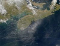 Satelite photo of Nova Scotia
 Atlantic and Fundy waters are relatively cold (8-12C), and they help to keep the air temperature over southwestern Nova Scotia on the cool side in spring and summer. In January, when their temperature is between 0 and 4C, these same waters moderate the harshness of winter. Farther offshore to the east, southeast, and south are comparatively warm 16C waters of the Gulf Stream. It's warmth, especially from August through October, is credited with prolonging fall -- the season many Nova Scotians consider to be the best of the year.
Nova Scotia's north coast is exposed to Gulf waters which, in late August, have a maximum surface temperature of 18C. The contrast between air and water temperatures is enough to create onshore sea breezes and to hold back the onset of fall for a few weeks. In January, however, Gulf of St. Lawrence and Northumberland Strait waters become ice-covered, effectively cutting off any marine influence for the next three months.
The influence of the sea is felt in other ways. Ice conditions in the Gulf and, on occasion, in the Bay of Fundy retard the arrival of spring. Cool summer seas also help stabilize overriding air masses, thus suppressing local storm development. In addition, the merging of contrasting ocean currents -- warm Gulf Stream and the cold Labrador Current -- produces a great deal of sea fog that often moves far inland.
The effects of latitude and relief on climate are not as important in Nova Scotia as elsewhere. The highest mountains are the Cape Breton Highlands, part of the Appalachian mountain chain, but nowhere are they higher than 530m. Although this is not high enough to block the movement of air masses, it is sufficient to divert them and cause them to move in a direction parallel to the mountains. Locally, the Highlands help to wring additional moisture from passing weather systems and to cool temperatures by 1 or 2C.
Warmest in the East
The southwest coast around Cape Sable is frost free for over half the year, longer than any other place in Atlantic Canada and comparable to localities along the shores of Lake Erie. Most agricultural areas experience a period without frost for 120 to 130 days between late May and early October, which is the effective growing season for most crops. The Annapolis Valley has up to 140 frost-free days, but the higher highlands on Cape Breton Island have less than 100 days.
Winter temperatures are moderate along the coast. Yarmouth's average January temperature of -2.7C is the highest of any mainland station in the Maritimes. Inland, January means are between -4 and -6C. The most significant aspect of winter is the marked day-to-day variation caused by the alternation of Arctic and maritime air.
Summers are relatively cool in Nova Scotia. Afternoon summer temperatures reach 25C in the interior, but along the coast are frequently 4 to 6C cooler. At night the ocean remains a cooling source, keeping minimum temperatures along the coast about 2 to 3C below those inland. Halifax's July mean of 1 7.4C and Yarmouth's 16.3C compare closely with Vancouver's 17.3C but are somewhat cooler than Toronto's 20.6C.
Mainly Moist
Nova Scotia is wettest over the highlands of Cape Breton Island, where over 1600 mm of precipitation fall in an average year. The southern coast experiences almost as much, with totals of 1500 mm. By contrast, the north shore along the Northumberland Strait has less than 1000 mm a year.
Precipitation is slightly greater in the late fall and early winter because of the more frequent and intense storm activity. In most years there is a good supply of rain during the growing period. However, drought is not unknown in Nova Scotia. A prolonged warm, dry, and sunny spring in 1986 contributed to the worst forest fire outbreak in the province's history. The previous summer, several months of below normal precipitation dried up wells and streams, and water levels did not begin to recover until Hurricane Gloria brought heavy rains in late September.
On average, only about 15% of Nova Scotia's total annual precipitation originates as snow. An exception is northern Cape Breton Island, where the snow fraction is closer to 30%. Snowfall is relatively light near the warm Atlantic shore and near the entrance to the Bay of Fundy, where less than 150 cm may fall in one winter. Here, copious rain and freezing rain make up for the scanty snowfalls. Inland, the yearly snowfall increases to 250 cm. As a rule, elevated areas receive the greatest snowfall and have the longest snowcover season. Both the Cobequid Mountains and the Cape Breton Highlands receive in excess of 300 cm in an average snow year. These elevated areas also experience "sea-effect" snowfalls in the wake of winter storms. Heavy local snowfalls are also produced by winds blowing off the open waters of the Gulf of St. Lawrence and the Bay of Fundy.
The snowcover season, that is, the period when there is at least 2.5 cm of snow on the ground, varies considerably. Usually its duration extends from about 110 days a year along the southern coast to 140 days inland and in areas adjacent to the frozen seas. In coastal areas the snowcover may come and go. At Halifax, for instance, there is only a 50% chance that there will be snow on the ground for Christmas.
Some of the more notable provincial snowfall extremes are--greatest snowfall in one season: 653 cm at Cheticamp in 1964-65; greatest in one month: 224 cm, also at Cheticamp, March 1961; and greatest in one day: 69 cm at Yarmouth on March 19, 1885.
Misty Sunshine
Halifax's reputation as a foggy and misty city is well deserved. Each year there is an average of 122 days with fog at the International Airport and 101 days at Shearwater, on the Dartmouth side of the harbour, although on most days fog persists for less than 12 hours. The period from mid-spring to early summer is the foggiest time. Bands of thick, cool fog lie off the coast, produced where the chilled air above the Labrador Current mixes with warm, moisture-laden air moving onshore from the Gulf Stream.
Besides Halifax, other foggy places are Yarmouth (118 days), Canso (115 days) and Sydney (80 days). No part of Nova Scotia is fog-free, although some places inland from the Minas Basin have no greater fog frequency than Toronto.
Sunshine totals range from 1700 to 1969 hours a year. July is the sunniest month inland, and August is the sunniest along the coast. Sunless days (days with less than 5 minutes of bright sunshine) amount to between 75 and 90 a year, with a marked seasonal high from November to February. Sunny days, on which less than 70% of the sky is covered with cloud in the early afternoon, amount to between 130 to 160, with a peak from July through October.
Winds
Winds blow predominantly from the south or southwest in the summer with an average speed of about 10 to 15 km/h. In the coldest months the predominant direction is from the west and northwest with an average speed of 22 km/h.
The wind at any given location is often quite different from the wind conditions which prevail even a short distance away. The variation that occurs in both wind direction and speed results from the characteristics of natural and man-made obstructions, topography, and surface cover. Along the coast, an onshore sea breeze circulation often sets up, particularly during a warm, sunny afternoon in the spring or early summer.
People
Nearly one-quarter of Nova Scotia's population of approximately 941 000 report the British Isles as their place of ethnic origin. Significant portions of the population also report either French or European origins.
Many residents of Nova Scotia are of German, Dutch, Polish, Italian, Jewish and Lebanese descent. After the War of 1812, several thousand Black people, including the Chesapeake Blacks, settled in the Halifax area; in 1996, more than 18 000 residents of the province reported having Black origins. More recent immigrants to Nova Scotia have included Chinese, Indo-Chinese, African, Asian and eastern European groups.
In 1996, the Aboriginal population of Nova Scotia was 12 380, mostly belonging to the Micmac Nation.
The largest concentrations of population are found in the Halifax metropolitan area with a population of approximately 329 000 and Cape Breton County (including Sydney) with approximately 117 000. Major towns include Yarmouth, Kentville, Bridgewater, Truro, Amherst and New Glasgow. Approximately half of Nova Scotia's residents are based in small towns, rural and coastal areas.
Economy
Nova Scotia's economy is highly diversified, having evolved from resource-based employment to include many types of manufactured goods as well as business and personal services.
The resources sector started with the sea and the teeming fish of the Scotian Shelf. The catch is comprised mainly of cod, haddock and pollock, as well as lobsters, scallops and crab. This resource, particularly cod, has been hit by dwindling stocks in recent years, and quotas are affecting those who derive their livelihood from this sector.
For a small province, Nova Scotia has a highly developed forestry sector with four pulp and paper mills and several hundred sawmills.
The mining sector is dominated by thermal and metallurgical coal production of 3.2 million tonnes. The province also produces 7 million tonnes of gypsum, over 70 percent of the Canadian total. Other mining activity includes salt, barite, crushed stone, peat and sand and gravel. Extensive exploration of offshore oil and gas has been undertaken in the past decade, and in 1991 the first commercial production of oil began near Sable Island.
Nova Scotia has a highly specialized commercial agriculture sector. Dairy is the largest sector, followed by horticultural crops, poultry, eggs, beef cattle and hogs. Export commodities include blueberries, apples and processed fruits, vegetables and juices.
Tourism is an important sector in the provincial economy. Total tourism receipts exceed $1 billion and over 30 000 people are employed in the many aspects of the industry. More than two million people visit the province each year, with almost one quarter of these coming from outside Canada.
The province's physical location has made it well-suited for industry and trade. Harbour facilities, modern highways, air transportation, industrial parks, research and education facilities all contribute to providing a varied and positive climate for business.
Transportation
Transportation in New Brunswick is served by a network of some 20,620 km (some 12,815 mi) of roads and highways. In addition, 1097 km (682 mi) of mainline railroad tracks cross the province. Because it is on the mainland of North America, New Brunswick relies less on water transportation than do the other Atlantic provinces. Saint John, however, is a major seaport, and it is also the terminus of the two major national railroad systems. Ice free in the winter months, the port handles 90% of the province's import and export traffic. Moncton has the busiest airport; Fredericton and Saint John also have major air terminals.
Getting Here
By Air
Nova Scotia is located two hours closer to Europe than any other mainland North American destination and its capital city, Halifax, is geographically closer to Boston and New York than any other major Canadian city. The Halifax International Airport is the Atlantic Canadian hub for all domestic, regional and international services. Visit FlyHalifax.com to view a list of airlines providing flight options to Halifax.
Scheduled air service into Nova Scotia is available from all major Canadian cities, from all major United States cities through connecting hubs at Boston and Newark, and from major European cities through the connecting hub at London. In addition, scheduled charter services are available linking Nova Scotia with many Canadian and European cities.
Limousine service and car rentals are available at the Halifax International, Yarmouth International and Sydney airports. There is a shuttle bus to and from hotels in the Halifax area. Call Nova Scotia's Check In Reservation and Information Service for further details (1-800-565-0000).
By Land
Highways from all points in the United States and Canada join the Trans Canada Highway from New Brunswick into Nova Scotia.
Greyhound from New York and Voyageur from Montreal connect with Acadian Lines which serves Atlantic Canada. At Amherst, intraprovincial bus lines link most major communities.
VIA Rail Canada provides transcontinental train service; there are stations in Truro and Halifax. Call toll-free 1-888-842-7245.
By Sea
Comfortable car ferry trips connect Maine, New Brunswick, Prince Edward Island and Newfoundland to Nova Scotia. As part of the Canada/New England cruise corridor, several major cruise lines also visit ports of call in Nova Scotia between early May and late October.