100 acres for Sale in Bass River, New Brunswick
Back to listings
A wonderful recreation/woodlot acreage located in Bass River New Brunswick. The property borders Crown Lands and has access to an amazing network of recreation trails for ATVing and snowmobiling. Excellent hunting and fishing!
| Lot Size: |
100+/- acres |
| Location: |
Smiths Corner / Bass River, New Brunswick. |
| Reference #: |
NB-2085 |
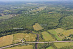
This photo shows HWY 116 and Allen Road to the 100 acre parcel.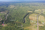
Drone photo overlooking the Smith's Corner region, HWY 116 and the Richibucto River. You can see the 100 acres in the distance.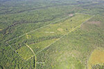
Overhead view of the property. The land was harvested for timbers in 2014.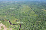
Looking in a northerly directly overtop of your property. Crown Lands adjoin your property on the north end.
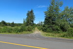
Looking up Allen Road from HWY 116. Your acreage is 1.1 kilometers up the road from here.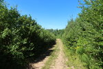
Allen Road and within the acreage - on both sides of the road. 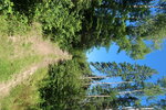
Continuing up the trail through the acreage. This photo was taken where the brook crosses up through the land.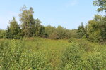
Picture taken on the acreage along the trail and just on the other side of the brook.
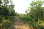
Following the trail that runs north / south along the westerly side of the acreage.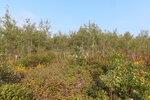
Photo taken on the land. Here you can see the good regeneration since the timber harvest.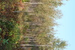
Picture taken on the land. 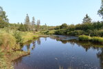
The Richibucto River near to the property. Recreation trails can take you right up to the river.
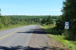
HWY 116 at Smiths Corner. Allen Road to your acreage is about a kilometer up the road just on the other side of the bridge over the Richibucto River.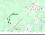
Topographic image highlighting the location of the acreage in Smiths Corner / Bass River region.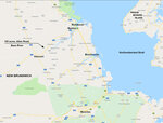
Map indicating the location of your property approximately 1 hour north of the city of Moncton.
Land located at Bass River, Parish of Weldford, County of Kent, and Province of New Brunswick. PID 25088717 & PID 25256785.
SIZE: 100+/- acres (40+/- hectares)
- Two parcels, PID 25088717 & PID 25256785, make up the acreage.
- Access via Allen Road off Highway 116 at Smiths Corner and also via the trails off from the Fishing Club Road from Bass River.
- Off-grid site, no power nearby.
- Dry, well-draining ground with a gentle slope and elevation ranging from 100 to 150 feet above sea level.
- A small brook crosses the property.
- Lots of wildlife around.
- Trail access to the Richibucto River.
- Borders recreation trail that connects you to almost endless wilderness trails and woodlands.
- Just a few minutes from the community of Bass River – general store, gas, post office, community centre.
- A 20-minute drive from the towns of Rexton and Richibucto.
- Within an hour from the City of Moncton.
This is a wonderful acreage located just a few kilometers southwest of the community of Bass River where you’ll find nice home sites, open farm fields, seemingly endless woodlands, and amenities including a general store, post office, church, K-5 elementary school, gas station and friendly hospitality. This is a great property for those looking to enjoy remote acreage for hunting, recreation, and investment in woodland that is connected to tens of thousands of acres of Crown Lands. Here you can enjoy an active outdoor lifestyle on a large acreage within a convenient distance from the city.
Your acreage can be accessed in two ways. The first route is through Highway 116 at Smiths Corner using Allen Road, which is listed as a public non-maintained road. To get to the property from the south, follow Allen Road for approximately 1.3 kilometers north from Highway 116. The second access point is through Fishing Club Road in Bass River, involving several kilometers of backroads and woods roads to reach the land from the north.
Topography of the land is relatively level, sloping down towards a small brook which carves it’s way across the southern third of the acreage. The average elevation above sea level is 140 meters.
The acreage was harvested for timbers between 2010 and 2015, and has since been pre-commercially thinned. Regeneration and tree growth is looking very healthy in a variety of tree varieties from Poplar, Birch, Maple, Fir, Spruce, and a few Pine. The forest supports a diverse natural habitat of wildlife and birds.
The Richibucto River is easily accessed via a trail from within your acreage, where you can fish for Trout, Perch and Smelt.
For hunting and outdoor exploration, this acreage is ideally situated and connected to nearly endless miles of backroads and wilderness trails that can be travelled on foot, by ATV, and through the winter months, by snowmobile, snowshoe and cross-country ski. The thousands of acreas of connecting Crown Lands make also make this a great spot for hunting, not only on your acreage but also on the adjoining lands. Deer, Moose, Bear and small game.
Follow Route 116 east via Bass River, Rexton, Richibucto to the Northumberland Strait (25 miles, or 40 kilometers, distant). Just north of Richibucto is Kouchibouguac National Park with miles of sand beaches along the Northumberland Strait. The Northumberland Strait is home to the warmest ocean water temperatures in Canada, with some areas reaching 77 degrees Fahrenheit or 25 degrees Celcius.
A short drive west of the parcel, along Route 116, will take you to the small community of Harcourt, where you’ll find a gas and convenience store, post office, church, K-5 elementary school as well as friendly hospitality. From Harcourt take Route 126 south to Moncton (30 miles distant), or north to Miramichi (43 miles distant). Follow Route 116 east past the parcel via Bass River, Rexton, Richibucto to the Atlantic Ocean (25 miles distant). Just north of Richibucto is Kouchibouguac National Park with miles of sand beaches along the Atlantic Ocean.
Getting here is easy. From Moncton, the province’s second-largest city and urban centre (population ~140,000), take exit 450 from Trans Canada Highway (HWY #2) onto Route 126 toward Miramichi. Follow Route 126 north for 50 kilometers to Harcourt. From Harcourt turn right onto Route 116 and follow for 9.2 kilometers to the unmarked Allen Road on your left. From here, follow Allen Road for 1.3 kilometers to your acreage.
PRICE: Term Sale: $55,000.00, payable $6,280.00 cash with order and eighty-four (84) monthly payments of $580.00 each, and interest. 10% discount if paid in full within 30 days: $49,500.00, if paid $5,000.00 cash with order and the balance of $44,500.00 within thirty days thereafter.

This photo shows HWY 116 and Allen Road to the 100 acre parcel.
Drone photo overlooking the Smith's Corner region, HWY 116 and the Richibucto River. You can see the 100 acres in the distance.
Overhead view of the property. The land was harvested for timbers in 2014.
Looking in a northerly directly overtop of your property. Crown Lands adjoin your property on the north end.

Looking up Allen Road from HWY 116. Your acreage is 1.1 kilometers up the road from here.
Allen Road and within the acreage - on both sides of the road. 
Continuing up the trail through the acreage. This photo was taken where the brook crosses up through the land.
Picture taken on the acreage along the trail and just on the other side of the brook.

Following the trail that runs north / south along the westerly side of the acreage.
Photo taken on the land. Here you can see the good regeneration since the timber harvest.
Picture taken on the land. 
The Richibucto River near to the property. Recreation trails can take you right up to the river.

HWY 116 at Smiths Corner. Allen Road to your acreage is about a kilometer up the road just on the other side of the bridge over the Richibucto River.
Topographic image highlighting the location of the acreage in Smiths Corner / Bass River region.
Map indicating the location of your property approximately 1 hour north of the city of Moncton.
Wolter Land Estates
449 Farris Road
Kelowna, British Columbia
V1W 1N1
Telephone: (250) 863-2425
Fax: (250) 764-4377
Email: land@wolterland.com


